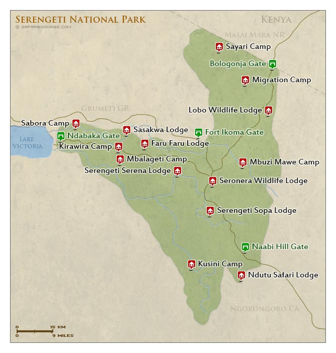
Serengeti National Park map. A Serengeti National Park map is one of the essential things to have whilst embarking on any Serengeti National Park safari any time of the year, especially for travelers new to the area. The Serengeti National Park map covers a wide area, encompassing not only the endless Serengeti Plains but also an amazingly beautiful and old ecosystem that has survived millions of years with little change to it over the years. Serengeti National Park area is also surrounded by various wildlife areas and conservancies like the Loliondo Game Controlled Area in the East, Maswa Game Reserve in the west, Ngorongoro Conservation Area in the south and the equally beautiful and sought after Masai Mara National Reserve in the north.
Serengeti National Park Location
Serengeti National Park is located in the northern part of Tanzania, making part pf the different northern safari circuit safari parks in Tanzania, most sought after by travelers who visit Tanzania. Serengeti National Park is partly adjacent to the Kenyan border, covering about 14,763 square kilometers. Serengeti National Park is located entirely in the eastern Mara region and the north eastern portion of the Simiyu region.
Due to the vast nature of the Serengeti National Park, the park is divided into different regions. Serengeti National Park has 5 different regions that travelers can visit all throughout the year. The Serengeti National Park regions include the Central region, northern region, southern region, western region and the eastern regions of Serengeti National Park.
Central Serengeti Region
The central Serengeti region is also called the Seronera Area, a popular and most sought after Serengeti National Park region with the Seronera River which is a big draw card to the different animals in Serengeti National Park as they come for a dip or drink.

At the Seronera River banks you shall see a number of animals including lions, elephants, buffalos, hippos and so much more. The Seronera Area also has some of the most amazing Serengeti National Park accommodation including lodges and camps that travelers can enjoy while on their Serengeti National Park safaris.
North Serengeti Region
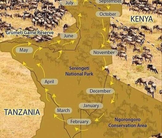
The north Serengeti region is the home of the great wildebeest migration that occurs especially in the months of June through October with travelers visiting this northern region of Serengeti having a high chance of witnessing the iconic Mar River crossing of the great wildebeest migration as they make their way to the Masai Mara National Reserve Kenya. The northern Serengeti region can be crowded during the months of June through October, but is a great area to stay for travelers after a bit of exclusivity in the other months of travel when the great wildebeest migration is not in season.
Eastern Serengeti Region
The eastern Serengeti region as per the Serengeti National park map covers the Grumeti River where the migration also takes place, as the wildebeest herds make their way through the Lobo area, western Loliondo. When in season, you would chance to witness the amazing Grumeti River crossing, a thrilling spectacle to witness.
Western Serengeti Region
The western Serengeti region is one of the Serengeti National Park regions that travelers can visit while on a Serengeti National Park safari, all throughout the year. The western area is a great Serengeti region to visit for a chance to spot out the patas monkey, black and white colobus monkeys, baboons, among so many other animals in Serengeti Park. Cheetahs and lions can easily be seen in the western Serengeti region.
Serengeti National Park Map
Getting to Serengeti National Park
There are two ways to get to Serengeti National Park that is by road and by air.
Getting to Serengeti National Park by Road
Travelers can get to Serengeti National Park by road by driving through Arusha town which is the starting point of most northern safari circuit safaris, to the park. The driving distance from Arusha to Serengeti National Park is about 7 hours. Though long, this drive has you driving through some of the most beautiful communities giving you an opportunity to see the countryside of Tanzania. You would also get to transit through the Ngorongoro Conservation Area, one of the most beautiful places of Tanzania.
Getting to Serengeti National Park by Air.
The aviation industry in Tanzania is quite developed, and because of the vastness of Tanzania as a country, domestic flight s and domestic airlines are many and thus competitive, availing different routes that travelers after flying safaris in Serengeti National Park can opt for. Domestic airlines like Regional Air, Flight Link and the rest have scheduled flights in and out of Serengeti National Park, covering the different regions of the Serengeti given the Serengeti National Park is quite. Depending on your base for your safari therefore, you can fly from Arusha, Dar es Salaam, Zanzibar or even Kenya and Masai Mara to the Serengeti.
Serengeti National Park is one beautiful true African wilderness safari destination that travelers can visit and be amazed at the sheer scenic beauty of the park. Get in touch with a reputable tour operator to help you pitch an amazing Tanzania safari tour, and visit the Serengeti National Park. Clad yourself with a Serengeti national Park map to help you identify your location.