Rongai Route : Only the Rongai Route departs from Mount Kilimanjaro’s northern, or Kenyan, side. Due to its remoteness, the path provides hikers with an experience in a relatively untamed wilderness where it is possible to encounter large animals like antelope, elephants, and buffalo. Trekkers have a lower chance of running into rain on the mountain’s northeast side because it receives substantially less rainfall than its southern slopes. Also, it is more likely for trekkers to see the peak in clear, unobstructed vistas.
Among the official Kilimanjaro hiking routes, the Rongai route is one of the least used. The benefit of this is that there won’t be many other climbers around, and you’ll spend the majority of the expedition traveling through untamed wilderness and breathtaking landscapes. The negative is that this route’s topography makes it difficult to acclimate because it is difficult to adhere to the “walk high, sleep low” philosophy, which is one of the reasons it is not mostly used compared to other routes like Machame route and Marangu route.
Starting at the Rongai gate, the journey travels through a number of distinct temperature zones, each of which offers breathtaking vistas and sensations. Due to its remoteness, the path provides hikers with an experience in a relatively untamed wilderness where it is possible to encounter large animals like antelope, elephants, and buffalo. On day two, when you ascend to Kikelewa Caves, you can see the Kenyan Amboseli Plains far off in the distance. The trail then ascends to Mawenzi, the mountain’s second top, before cutting over the saddle, a desolate plain that connects Mawenzi and Kibo. You have the opportunity to see Mount Kilimanjaro from both sides as you descend after reaching the summit by the busier Marangu path.
KILIMANJARO HIKING VIA RONGAI ROUTE: HERE’S OUR COMPLETE GUIDE TO THE RONGAI ROUTE.
Rongai Route 7 Day Itinerary Overview
Starting at Rongai Gate, ascending to the top, then returning to Marangu Gate. The six-night and seven-day Kilimanjaro climb using the Rongai route is detailed in the itinerary below. You can cut the schedule below in half by omitting the third cave’s overnight stay and instead walking directly from the Mawenzi Turn Hut in only one day.
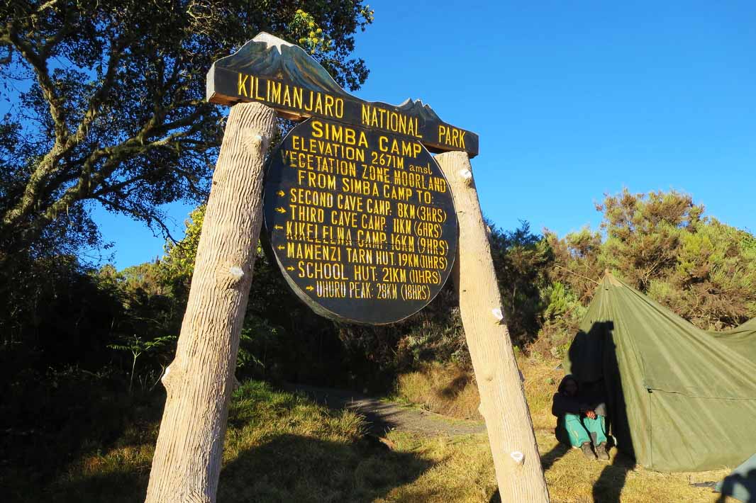
DAY 01-NALE MURU TO SIMBA CAMP
The journey to Nale Moru, a magnificent wooden settlement, takes you through villages and coffee fields. Where you meet the porters on the mountain’s northeast side. The dense jungle that the trail passes through in the beginning quickly lightens on the arid north side. You will soon arrive in the area of heather. Spend the night in the tent at 9,300 feet in elevation at the First Cave Camp (Simba Camp). With a stunning view of the Kenyan plains, Simba Camp is situated close to First Cave.
- 4-5 hours for a hike
- Altitude at Night: 9,300′
DAY 02-SIMBA CAMP – SECOND CAVE
The schedule for today starts early in the morning with a steady ascent to Second Cave. The route passes through a huge area of heath that is characterized by heather, wild flowers, and stony roads. You can take in the vista of Kibo and the crater rim’s east-facing glaciers as you stroll. You will leave the main trail after lunch and follow a more condensed route up to the craggy Mawenzi peaks. Finally, you will arrive at “Second Cave,” a protected valley next to Kikelewa Caves that is ringed by enormous senecio trees.
- Hiking time: 3-4 hours
- Overnight Altitude: 11,300 ft.
DAY 03: SECOND CAVE-THIRD CAVE
In order to increase your chances of reaching the summit and lower your danger of experiencing the consequences of altitude sickness, this day has been set aside for acclimatization. Relax and simply take in your surroundings for the morning. After lunch, it’s time to leave the camp and cross the heath, heading in the direction of Third Cave and the craggy peaks of Mawenzi.
- Hiking time: 3-4 hours
- Overnight Elevation: 11,811 ft.
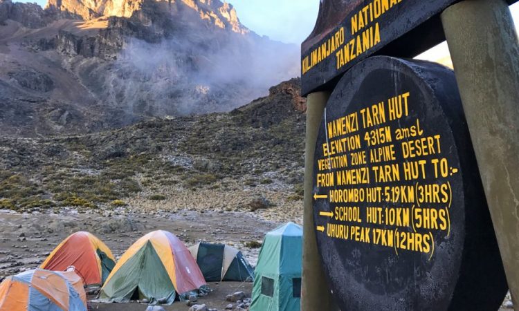
DAY 04: THIRD CAVE-MAWENZI TARN HUT
You arrive at Mawenzi Tarn Hut on the stage for today. You will receive a wonderful panoramic view as compensation for your short but difficult ascent up the grassy mountainside. Heathland gives way to Rocky Mountains that are covered in big and small volcanic stones as a reminder of earlier volcanic activity. The location of your overnight lodging, which boasts a breathtaking setting, nestled in a valley between the towering spires of Mawenzi, will be reached after a few more hours of hiking on the trail.
- Hiking time: 4-5 hours
- Overnight Altitude: 14,160 ft.
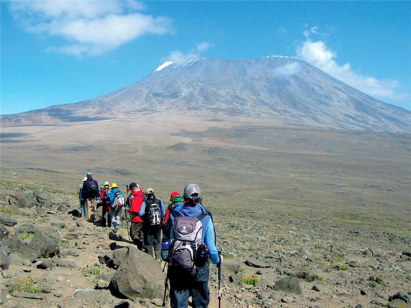
DAY 05: MAWENZI TARN HUT- (KIBO HUTS)
Now that Mawenzi and Kibo are connected, you will find yourself traversing the almost lunar region known as “The Saddle.” It’s time to get your gear and warm clothing ready for the hike to the summit the next day when you arrive at Kibo Huts, which are situated at the base of the Kibo crater wall. Drinking water should be kept in a Thermos to prevent it from freezing solid. In order to ensure that your “human batteries” are completely charged for Kilimanjaro’s ultimate challenge, spend the remainder of the day unwinding and getting a good night’s sleep.
- Hiking time: 6-8 hours.
- Overnight Altitude: 15,430 ft.
DAY 06: KIBO HUTS – GILMAN’S POINT – UHURU PEAK – HOROMBO HUTS
Around midnight, you’ll be awakened, and you’ll have just enough time for a quick lunch before heading out into the night. The rough terrain, where the trail is strewn with loose stones, is generally regarded as the most difficult part of the ascent. The goal is to get to Gilman’s Point before dawn so you can get to Uhuru Peak, Kibo’s highest point, just after sunrise. Before continuing along the crater rim to Uhuru, you will make a quick halt at Gilman’s Point to take in the breathtaking scenery.
Your final destination, Uhuru Peak, the summit of Kilimanjaro and the highest point in Africa, may experience snow depending on the time of year. Once you’ve reached the peak, which is located at a height of 5,895, you can congratulate yourself, take in the breathtaking scenery, and have your photo taken in front of the Uhuru Peak sign as a memento of your accomplishment.
The descent to Kibo Huts may now begin, and you’ll see that it goes by surprisingly swiftly. You will stop for a well-earned lunch in Kibo Huts before moving on to Horombo Huts, where a much-needed night’s rest is waiting.
- Hiking time: 4-5 hours
- Overnight Altitude: 12,205 ft.
DAY 07—HOROMBO HUT (3,720 METERS) TO MARANGU GATE (1,870 METERS)
It takes about 20 miles to travel from Horombo Hut to Marangu Gate (1,870 meters), making it a lengthy day. Since the trip the day before will have left your knees sore, descend gently and watch your step while using your trekking poles to lessen the force on your joints.
You will now sign out at Marangu Gate, where you signed in six days earlier. A green certificate will be given to those who reached Gilman’s Point but did not proceed any further. A gold certificate will be given to trekkers who reach Uhuru Peak. At this point, the majority of trekkers give their porters and guides their well-deserved tips before being brought back to their hotel for a well-earned hot shower.
- Trekking distance: 20 kilometers (13 miles)
- Trekking time: 5-7 hours.
- Zone: rainforest
- Overnight Elevation: 1,843 ft.
RONGAI ROUTE FREQUENTLY ASKED QUESTIONS
Is the Rongai Route the easiest route up Kilimanjaro?
The Rongai ascent is thought to be the simplest ascent of Mount Kilimanjaro. The ascent is both easy and steady. Though it is debatably more difficult than the Machame or Lemosho climbs, the Rongai Route does not have a great climbing high-low profile. The 7-day trek option is strongly advised as it provides for better acclimatization. A certain level of fitness is necessary, but there is no need for technical climbing.
What is the distance between the Rongai Route and how many days does it take to complete the summit?
The Rongai Route can be hiked for 79 kilometres (49 miles) in total. The minimum amount of time needed for the Rongai Route is six days, but once arrival and departure days are taken into account that number increases to nine or ten. To enhance your chances of success, it is actually recommended to do the mountain’s easiest way over a period of seven days.
What is the Rongai Route Summit Success Rate?
The lengthier journey alternative significantly raises the summit success rates for the Rongai Route. Although there is no official data, the average success rate for the 7-day trek across all operators is 80%, and the success rate for the 6-day trek is 65%.
What is the scenery like on the Rongai Route?
The sole approach to Mount Kilimanjaro from the north, close to the Kenyan border, is through the Rongai Route. The Rongai route is less congested and travels through wilderness regions in isolation.
It is perhaps the only path where it is possible to encounter wildlife in the early going. Before reaching the glacier zone, you ascend via moorlands, high alpine zones, and then through the rainforest.
When is the best time to trek the Rongai Route?
The best months to climb Kilimanjaro are July through September since the weather is the most consistent and experiencing rain is less likely. Nevertheless, given its proximity to the equator, the peak can be climbed at any time of the year.
It is recommended to avoid the months of April and May because they are wet. The months of May and November are also suitable times to complete the journey because the Rongai Route is located on the northern side of Kilimanjaro and is in a rain shadow.